
Hiking Acatenango and Fuego Volcanoes in Guatemala: A Guide with Personal Stories
- Ilse

- Jan 23, 2024
- 10 min read
Updated: May 22, 2024
Imagine sitting on the ridge of an active volcano, searching for constellations in the crystal-clear night sky as you wait to watch lava to shoot into the air, while being cuddled up with two practical strangers you just met in an attempt to protect yourself from the freezing cold.

How did I find myself sitting on the ridge of an active volcano, cuddled up with two practical strangers in the freezing cold, looking at the stars, waiting for lava to erupt into the night sky a few meters away from me, feeling extremely alive?
The story as to why I came to Guatemala is a longer one, but what I can tell you now is that before coming I was very unprepared. I had booked my flight, the first hostel and that was it. So when packing one day prior to my flight I looked up the weather conditions in Guatemala, I was pleasantly surprised to learn about the Acatenango Hike near Antigua. Hiking up an active volcano? Sign me up for that!
Since this was the first place I would go on my longer backpacking trip, I decided I would save some space in my luggage with clothes specifically for this hike:
a fleece seater
a hat
tights (to wear underneath sport leggings)
extra warm socks.
From my brief research online, I learned that I would be able to borrow or rent more warm clothes from a touring company.
In this blogpost I will share practical information on the hike and what you should know before you go, the itinerary, and essential tips and advice based on my experience.
Practical information about the volcanoes Acatenango and Fuego
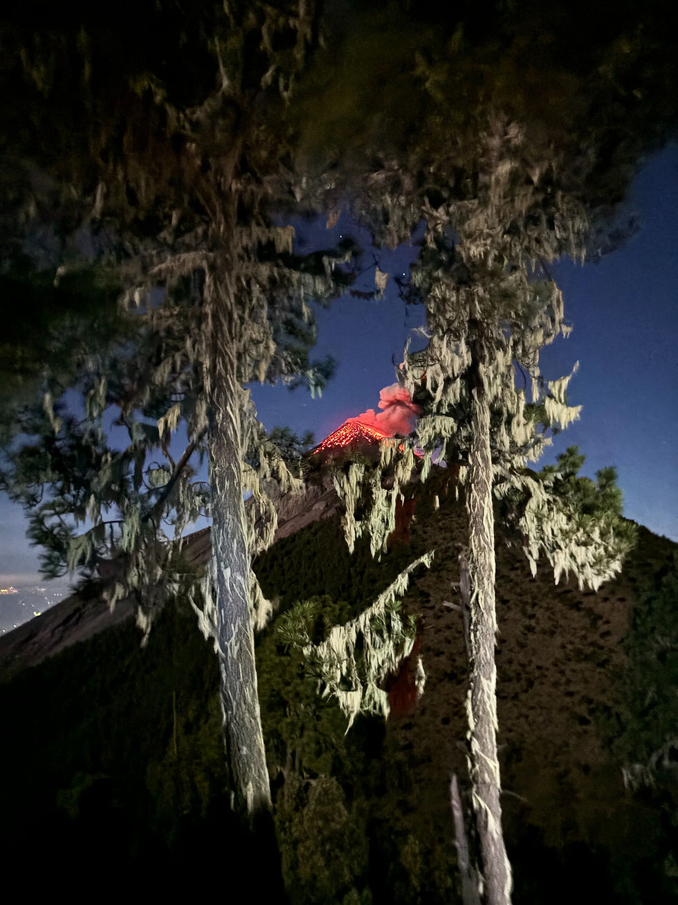
Acatenango is a stratovolcano that has two principal summits: Pico Mayor and Yepocapa, also known as Pico Chico or Tres Hermanas. Acatenango's summit is at 3.976 meters (13.044 feet), making it the third highest peak in Central America. Whereas Acatenango's last eruption was in 1972, it is part of a volcanic complex that includes the active Volcan Fuego which erupts several times an hour. Volcán Fuego is located about 2km (1.2 miles) to the south of Acatenango.
Fuego is one of the most active volcanoes in Guatemala, erupting frequently and sometimes violently and forms part of the Pacific Ring of Fire. Characteristic of this actively erupting volcano is that its eruptions often include a fountain on lava shooting into the air, rather than 'mere' clouds of ash.

Fuego's activity can be seen from the summit of Acatenango, making Acatenango a famous and stunning hike. However, to make your experience even cooler (literally, as you will read later) there is also the option of doing an additional hike from Acatenango to Fuego itself. Although depending on the conditions, this gives you the chance to see Fuego erupt from several hundreds of meters distance!
Practical information Acatenango and Fuego hike
How to go?
As a visitor your best option to climb Acatenango and Fuego is with one of the guided tour companies. These tours are generally two days, meaning you spend one night at basecamp. Honestly, the tours are pretty similar and everyone that I heard about it had positive experiences regardless of what touring company they went with. The prices range from around 40 euros to 100 euros (900 Quetzales) and are mostly dependent on the number of meals you get, the sleeping arrangement (tent, tent in cabin, or cabin with beds), whether warm clothes are included or come at a small rental price, size of the group, and the language or expertise of the guides. I went with Soy Tours but have heard positive stories about other tours as well.
At your hostel or at the tourist information point they can probably tell you about the different options and tours. You do not have to book weeks in advance, but a few days in advance is advisable to make sure there is still space! In general, it also recommended to stay in Antigua (which is at 1500 meters altitude) for a few days to acclimatize and prevent (as much as possible) getting symptoms of altitude sickness.
Elevation gain and distance
The elevation gain from the trailhead to the summit is about 1.600 meters (5.253 ft) and the total distance of the hike to the Acatenango summit is about 13.8 kilometers (8.6 miles), plus an optional hike to Volcán Fuego which is another 2 kilometers to go and back.
Itinerary and my experience
Itinerary: Day 1
You will likely picked up at your hostel by shuttle to drive to the tour company building where you get some explanation, food and you will have the opportunity to rent/borrow warm clothes, buy some more snacks and water. Then from there you walk to the starting point.
On the first day you will climb up around 1.100 meters to basecamp which is at around 3.700 meters (12.000 feet) and takes about 4 to 5 hours. From here you can do the optional additional hike to Fuego and back. This means another 475 meters elevation and 475 meters of inclination (1.550 feet), which takes another 2 to 4 hours including spending time on the ridge, awaiting the next eruption.

Part of our group already saw one eruption right as we hiked over the point where Fuego was in sight again. Unexpectedly, it just exploded and shot out balls of fire and a fountain of lava! For some reason I had thought that the eruption would only consist of lava flowing over the edge, so I screamed out of surprise and excitement. Everyone that saw it clapped and was overjoyed to have witnessed such a powerful natural phenomenon.
When the whole group had come up, we made our way to the ridge to sit down and await another eruption. On the ridge you are
fully exposed to the wind, sitting in literally freezing temperatures. So make sure you dress warm when leaving basecamp, even if at basecamp it does not feel that cold yet! Especially when the sun is down, temperatures drop quickly at this altitude. For me this meant cuddling up with the strangers I had just met, which was a fun and crazy experience in itself. We also had a crystal-clear night sky, meaning I could see the stars AND a red moon coming up right after sunset. Sitting up there I felt so ALIVE!
Good to know is that while the part of the group that stays at basecamp will have dinner and sit around the fire around sunset, the Fuego group will only have dinner after the hike. Which is around 22h at night. Meals are included in the tours, but I was very happy that I had brought a whole extra egg sandwich that I ate before going to Fuego. On the way back I was very hungry, so I cannot imagine how hungry I must have been if it weren't for that egg sandwich!
The hike back to basecamp was challenging, but in my opinion very doable. One of our guides had put on some music and we were fueled by the excitement of having seen the eruption from so close. I focused on the feet in front of me, not thinking about the distance and inclination we had left, lost in my own thoughts and reliving this magnificent experience in my head already.

Once we arrived at basecamp, dinner was ready and there was hot chocolate. I ate it quite quickly and made my way to the tent. There I laughed at my tent roommate who was tucked away in her sleeping bag, wearing all her layers so that just her eyes were showing. I put on all my layers, including my gloves, except my winter coat and went to lay in my sleeping bag. I slept really well and did not feel cold. My neighbour barely slept and was cold.
Here is what I was wearing from top to toes:
hat
sports bra
long sleeved semi thermal shirt
cotton short sleeved blouse
fleece sweater
tights, sports leggings
pair of sweatpants (from the touring company)
one pair of normal hiking socks
one pair of ski socks that I had brought from home specifically for this hike.
The difference was made by these socks! From the people that I heard had been cold at night, mostly had cold feet. So, bring that extra pairs (yes plural) of socks! It will only take up a small portion of your backpack and it will be worth the good night of sleep.
Itinerary: Day 2
The second day you will make your way up to the summit at 3.976 meters (13.044 ft) for sunrise, head back to basecamp for breakfast and to pack your bags, before making your way down again.
We woke up around 4am to make our way to the summit. This was the hardest part for me as I could feel my legs from the day before. I walked very slowly and took a lot of breaks and with that I made it to the top comfortably. The view was amazing. We were lucky with a clear view on Fuego, seeing it erupt several times more, and a nearly cloudless sunrise. However, it was very cold. I tried to take photos with my camera and phone, but my hands could not be outside of my gloves for too long before it felt like they were freezing. So, if you want to take photos, consider bringing or investing in a pair of gloves with the special fingertips so you do not have to take them off to manage your camera!

After the sunrise we made our way back to basecamp, where we had breakfast. Then we packed our stuff and started making our way down. This only took 2 to 3 hours. On the way back I had more breathing capacity for conversations and so I talked with many people from the tour. At first I thought it might feel strange in such a big group (we were nearly 40), but it turned out that it only gave more possibilities to connect with people and have good conversations!
I talked about philosophies of life, the Japenese Zen buddhist concept of ikigai, meditation and breathwork, healing journeys and plantmedicine. Along with the memory of the hike and the eruption, these conversations provided me with energy for days to come!
Around noon I arrived back to The Purpose Hostel in Antigua (which I can HIGHLY recommend!!) where I had been the nights before. I had booked one more night there and decided to extend it with another so that I could get another day of rest before continuing my travels.

Tips & Advice: what to bring and what NOT to bring
this was one of the most incredible and cool (again, literally) experiences of my life thusfar! Seeing an active volcano EXPLODE reminded me of the immense power of our beautiful earth, similar to what I felt when I experienced my first earthquake in Xela, Guatemala.
Here are some essential tips that will make the hike(s) much more comfortable:
🏞️ The elevation gain to Acatenango basecamp (at 3700m) is 1100m and to Fuego is an additional 475m up and down the same day. Most people stay in Antigua (at 1500m) for a few days to limit chances of getting altitude sickness by adapting to the altitude already.
⛅️ Dress in layers!!! You do not want to have all your clothes on at the beginning of the hike as it gets hot in the sun, but a little bit into the forest it might rain a bit and up there you will need a sweater. Especially at night!
🥪 If you are going to do the extra hike up to Fuego (the actual erupting volcano), know that dinner will not be until AFTER this hike. I brought a whole baguette egg sandwich that I ate before the hike, which I was very grateful for during the last bit of the way back to basecamp. I can recommend bringing a significant snack for the Fuego hike.
🧦 Bring enough thick pairs of socks. I had woolen socks for wintersport with me and was very comfortable at night. My neighbour barely slept because her feet were freezing. All the layers on your body will not do much if your feet are cold, so bring multiple extra pairs to be safe!
💦 Do NOT bring 4L of water up. I brought 3,5 and only drank about 2L. I know of no one who brought too little and most even left liters of water up before going down. You will be able to take from someone else if 2-3L is not enough for you.
🔥 Do Fuego!!!!! It is not as hard as people say. The excitement for the eruption will keep you going on the way, and you can use the excitement from having seen the eruption for the way back. (And if you are struggling the key is to just focus on the feet in front of you. Do not think about how long you still have to go, just focus on the next steps😌)
What next?
After arriving back to your hostel where you will be dropped off by the shuttle you are going to want to have some rest. I recommend booking your night(s) at the hostel a few days before you leave for the hike so that you are guaranteed a spot in the same hostel you were the days before. You can usually leave the luggage you will not bring to the hike in a locker.
Since I had already spent over a week in Antigua, I left for my next destination soon after the hike. I had booked one night and decided to extend it with one day, so I had another day off before my travel day. If you have not spent much time in Antigua yet, I would recommend staying there for a few more days as there is a lot to do.
Like I said, hostel wise I would really recommend The Purpose Hostel, Antigua. From multiple people I have heard that it is one of the nicest hostels they have stayed in during their travels in Central America. There is a roof terrace with yoga mats to use, there is a working area, and the rooms are not too big (I slept in a 4-bed female dorm). Overall, the vibe is really chill, and the staff is super friendly. They will be able to give you recommendations for (vegan) food, hikes, and other things to do.
After Antigua many people make their way to Lake Atitlan, for example to San Marcos or San Pedro. A place that is often skipped is Xela (or Quetzaltenango), but this is such a shame! I went to Xela after Antigua and am currently renting a room there as my work is online and I am slow travelling. Xela is primarily known for the many hikes around, such as the Santa Maria volcano hike (which is another actively erupting volcano!), and the natural sauna and hot springs.
Xela is also close to Tajamulco, the highest volcano in Central America!
I will post my experiences, tips & advice on some of these hikes and locations in upcoming blogposts, so stay tuned! You can sign up to the newsletter and/or follow me on instagram for updates :)


Comments